New Rainwater Basin Spring Ponding Data Available
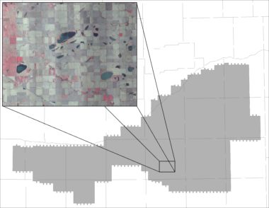
Waterfowl stopping over in the Rainwater Basin region during spring migration are looking for two basic resources, food and water. Since playa wetlands are strictly rain-fed, aside from some groundwater pumping on a few public properties, we have little control over how much water is available for waterfowl each year. Measuring the amount of water in RWB wetlands during spring has been a priority for the Rainwater Basin Joint Venture since 2004. Each spring during the peak of snow goose migration, right after the snow and ice melts in March, a single engine airplane affixed with a high-tech camera crisscrosses the RWB region, collecting images of each wetland footprint. We bring these images back to the “lab” here at the RWBJV Science Office and use specialized software to process the imagery to highlight all the areas of standing water and wetland vegetation. Employees then check and double-check each footprint for accuracy. Completing the Annual Habitat Survey (AHS) is a long and tedious process but the outcome is an informative dataset that has been used for a wide variety of research and planning efforts.
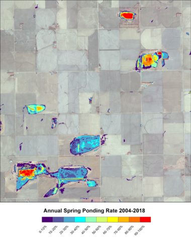
water ponding over an 8-year period.
Researchers at the University of Nebraska have used the AHS data to compare amounts of ponded water between conserved and non-conserved wetlands. Another lab at UNL used AHS data to make predictions about future water conditions under potential climate change scenarios. Another study, conducted by researchers at Kansas State University, used AHS data to explore how future wetland losses might impact connectivity of habitats for wetland-dependent wildlife with limited dispersal distances. RWBJV Science Staff has used AHS to determine how much wetland habitat, and the foods that waterfowl and shorebirds eat in wetland habitats, is available in a typically year. This information helps us to better target future projects to make the biggest impact, and measure our progress along the way.
AHS data has been collected each spring for 16 years (2004 and 2006-20). The RWBJV has plans to continue this program in 2021 and beyond. With recent advances in the quality and availability of satellite imagery, we are exploring a switch from using aerial imagery to using European Space Agency (Sentinel) imagery. Fourteen years of data, as most recent as 2018, can now be downloaded on the ScienceBase website. If you have any questions about how to use the AHS dataset, please contact Dana_Varner@fws.gov.
