

News
Online Mapping Portal to Streamline Grassland Conservation Delivery
April 10, 2026
 The RWBJV routinely works with partners to streamline conservation delivery in Nebraska. Through customized programs and decision-support tools, the RWBJV partnership collaborates to overcome implementation bottlenecks and maximize on-the-ground conservation investments. The latest tools is a new online mapping portal to help RWBJV partners deliver $18.8 million in NRCS funding through a recently awarded Regional Conservation Partnership Program (RCPP). This RCPP will positively impact at least 90,000 acres of Nebraska’s core grasslands.
This RCPP builds on the Great Plains Grassland Initiative (GPGI) that emphasizes follow-up management to hedge against future encroachment or re-infestation of treated acres. RWBJV partner biologists across the state will work one-on-one with producers to implement sustainable management practices to reduce the vulnerability of Nebraska’s core grasslands to woody encroachment. The program is available statewide, though priority enrollment eligibility is determined by a combination of factors, including location within GPGI priority areas (plus the Central Loess Hills), encroachment risk, and commitment to follow-up treatments. The RCPP funding will allow RWBJV partners to develop additional projects through their networks, using their grassland conservation funding to impact more acres. To be eligible the Land Management Practices have to align with Environmental Quality Incentives Program (EQIP) practice scenarios and be implemented in line with NRCS standards and specifications.
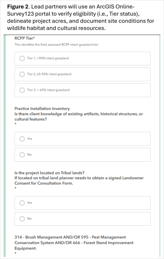
Recognizing that not all RWBJV partners are familiar with NRCS standards and specifications, the RWBJV Science & GIS Office developed an online mapping portal to streamline the application process. Lead partners will use this ArcGIS Online-Survey123 based portal to verify eligibility (i.e., Tier status), delineate project acres, and document site conditions for wildlife habitat and cultural resources. Once a proposed project is mapped in the portal, partners enter practice details in desktop GIS. This is a custom ArcGIS toolbox that automatically generates a report outlining cost-share estimates and conservation measures to avoid/minimize impacts to threatened & endangered species as well as cultural resources. All resource assessments, maps, and conservation measures generated through the portal and mapping application are consistent with NRCS programmatic agreements with U.S. Fish and Wildlife Service (USFWS) and State Historical Preservation Office (SHPO). These reports become part of the application package and guide implementation with key details (i.e., acres, type of practice, conservation measures, project deadline, etc.).
Not only does this portal streamline the application process for partner staff; it also simplifies the review and approval process for NRCS. A complete application will include producer information, practices, and RCPP cost-share, partner contributions, the map packet, and a greatly simplified Conservation Practice Application 52 from required by NRCS. Once the full application has been submitted and reviewed by the RCPP Coordinator it will be forwarded to the NRCS Point of Contract (POC) for review. The goal is to go from landowner contact to application in two weeks. If eligible and compliant, the RCPP Coordinator will then work with partners to secure bids, as needed, develop contracts and implement projects. If successful, this one-month process will reduce application timelines by 90% compared to a traditional EQIP contract. NRCS and the RWBJV have contingency measures in place for sites that require more detailed review or to avoid impacts to Threatened and Endangered Species or cultural resources.
 Though the streamlined application process and improved workflow between RWBJV partners and NRCS are notable by themselves, the utility of the mapping portal does not stop here. The portal also functions as a decision-support tool, leveraging RWBJV conservation planning and project tracking database. This RCPP is specifically designed to focus conservation delivery in- and around core grasslands where additional investments can most effectively reduce the threat of woody encroachment. Grassland tracts with low levels of woody cover and/or adjacent to existing partner investments (i.e., tree removal, prescribed fire) are designated with higher priority for enrollment.
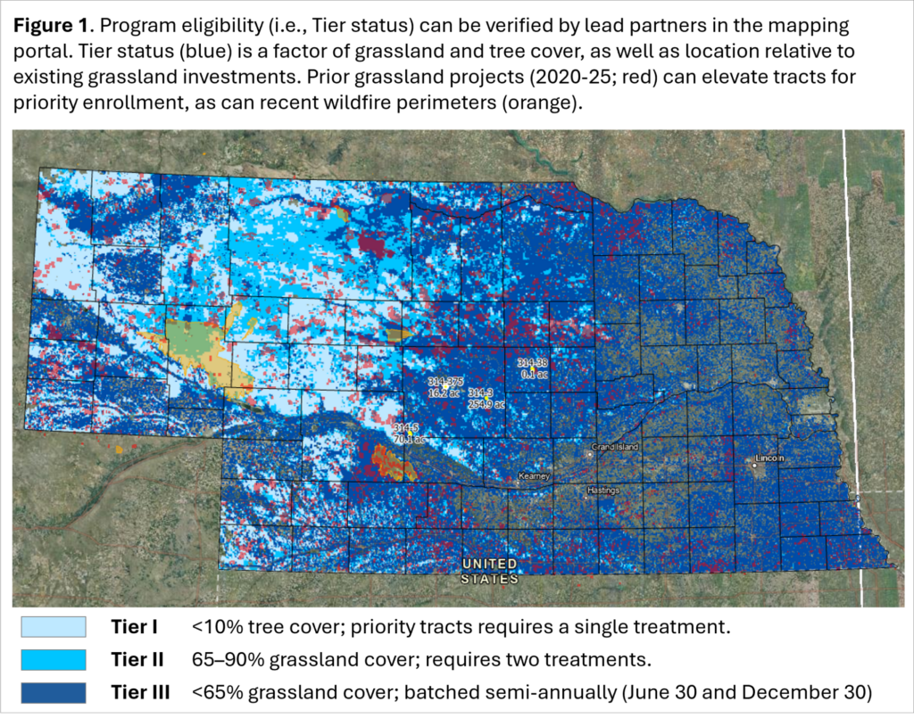
To prioritize tracts, the mapping portal leverages geospatial data from the Rangeland Analysis Platform (RAP) as well as the RWBJV project tracking database. The portal categorizes all grassland tracts identified in the Farm Service Agency (FSA) Common Land Unit (CLU) by tree canopy cover and project history, assigning a relative priority (i.e., Tier I, II or III). Projects entered in the portal are referenced against the tracking database which could elevate the priority based on management history for neighboring project sites. For example, a tract that may initially qualify as a Tier II based on canopy cover can be elevated to Tier I if there is a record of prior management. Recent projects are limited to those completed within the previous 5 years to align with management return intervals for grasslands.
This dynamic Grassland Tier layer is continuously updated as new project information is available either through portal submissions or additional contributions from RWBJV partners. Lead partners can contribute additional records to the portal that demonstrate adjacent projects (i.e., a complete burn plan, brush management plan, tree removal invoice, etc.). Access to this layer allows lead partners to review and screen projects to confirm eligibility.
Access to the mapping portal is restricted to program administrators and lead partners who have been trained in its use. Limiting portal access ensures that sensitive information is protected and data sharing is consistent with agency policies.
Throughout the program, RWBJV GIS Specialist, Roger Grosse, will ensure that online portal is operational and updated as new information becomes available. Roger will also be available as a resource to partners who want assistance or experience technical difficulties with the portal.